Asheville, North Carolina sits pretty (to say the least) within the embrace of the loftiest mountains in the eastern United States. These highlands are a real crown jewel of America’s landscape, and their seductive Southern Appalachian realm—verdant slopes, mystic coves, whitewater ravines, knobby peaks, long backbone ridges, sun-drenched balds beckons at Asheville’s doorstep.
Give in to the siren call of those heights and devote part of your AVL getaway to exploring them. The following is a resplendent lineup of summits in Asheville’s vicinity (and, to give the sluices some love, one waterfall-touring trail) forming a pretty unbeatable beyond-town itinerary.
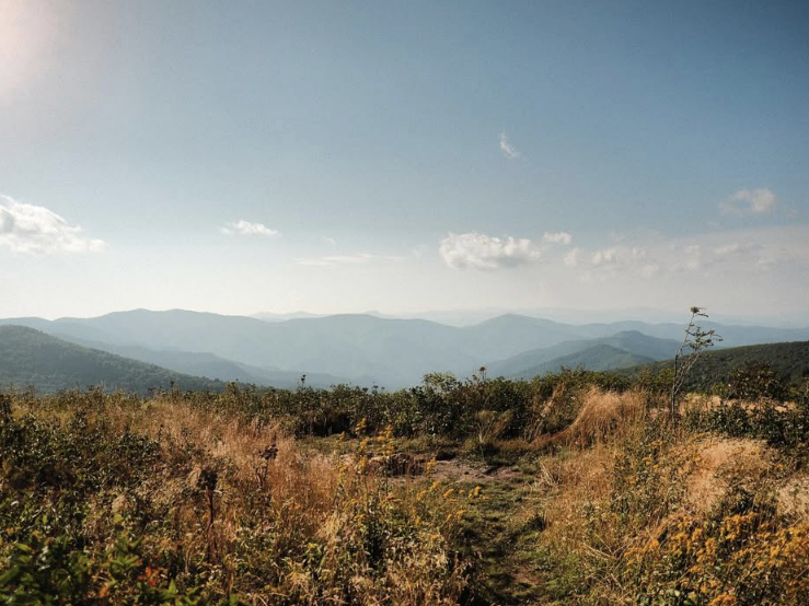
Max Patch
Photo Credit: @appalachiantrail
GPS Directions Here — 1.5 Miles Round Trip (Loop to Summit)
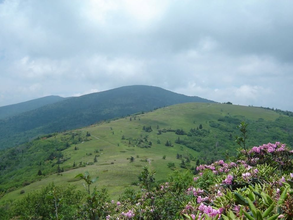
Although the Southern Appalachians don't rise high enough to hit the regional climatic timberline, many ridge-crests, saddles, and mountaintops support the tantalizing high meadows and shrublands, some of the only openings in this densely forested kingdom called "balds." Arguably the most celebrated of all is that broad grass bald in the (ahem) Bald Mountains called Max Patch, set at about 4,629 feet near the Tennessee-North Carolina line, within an hour-and-a-half of Asheville in the Pisgah National Forest.
The Appalachian Trail cuts across Max Patch, which many argue delivers that iconic long-distance footpath's single grandest view. If you aren't getting here by the "A.T.," a short, steep loop trail climbs to the bald from the Pisgah National Forest's Road 1182, just 1.5 miles round-trip from the gravel parking area. The Bald Mountains have a central-ish position in the complex of ranges forming the pinnacle of the Southern Appalachians, and from the pastoral vantage of "the Patch," the viewshed encompasses a royal swath of that soaring country, 360 degrees of layered ridgelines stretching into both North Carolina and Tennessee. You can also, rather uniquely, survey a couple of hundred miles of the Appalachian Trail's footway through this magnificent terrain.
Mount Pisgah
Photo Credit: @leimajesty
GPS Directions Here 2.4 Miles Round Trip (Out-and-Back)
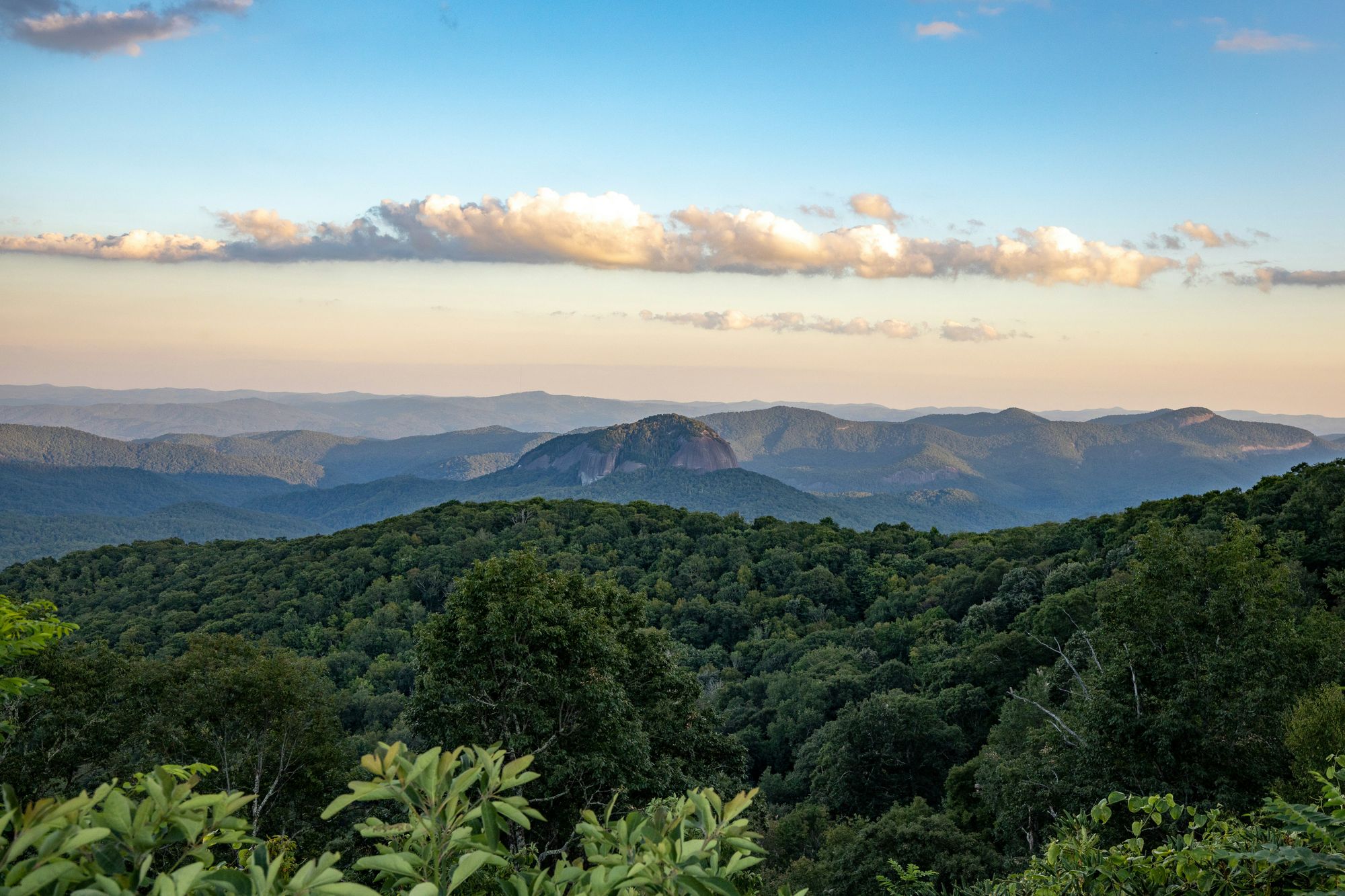
The lush, blocky tooth of 5,721-foot Mount Pisgah creates one of Asheville's signal peaks — a skyline fixture, a signature landmark of the Blue Ridge Parkway, and a mountain with a rich backstory. A mere 16 or so miles southwest of downtown at Parkway Milepost 407.6, the mountain's a pilgrimage, and the hike to the top is a satisfying balance: relatively short, but strenuous enough to deliver a genuine sense of accomplishment.
From the Parkway trailhead on the flanks of Little Pisgah Mountain, the route climbs through hardwood forest and mountain-laurel thickets, which explode into bloom in late spring, to the heath bald and transmission tower at the Mount Pisgah summit. You gain roughly 700 feet of elevation, with the second half turning into a rocky, continuous staircase through the canopy. The tower's observation platform delivers a knockout panorama: Fryingpan Mountain (home to a historic fire lookout tower well worth its own outing) to the near southwest, magisterial Cold Mountain westward, and the cliff-girt monolith of Looking Glass Mountain to the south.
Mount Mitchell
Photo Credit: @blairmeeks
GPS Directions Here — 4.4 Miles Round Trip via Old Mitchell Trail (from State Park Restaurant)
Only about an hour or so from Asheville, Mount Mitchell State Park among the oldest state parks in the nation protects the eponymous peak in the Black Mountains that, mounting to 6,684 feet, forms the highest point in the eastern U.S. Once called Black Dome, Mount Mitchell was renamed by the U.S. Geological Survey in the early 1880s to honor Elisha Mitchell of the University of North Carolina. Decades before, he'd proved the peak was loftier than New Hampshire's Mount Washington, once suggested to be the East's tallest mountain and yet, in fact, overshadowed by dozens of "Southern Sixers" (as peakbaggers call the 6,000-plus-foot summits of the Southern Appalachians).
You can steer a vehicle up to the observation deck atop Mount Mitchell, or earn some bragging rights by achieving it via a 4.4-mile round-trip hike along the historic Old Mitchell Trail beginning from the state park restaurant and climbing entirely above 6,000 feet in elevation. A goodly chunk of that trek passes through stands of the evocative upper-elevation spruce-fir forest that darkens the highest Southern Appalachian ridge-leads and summits (hence the whole "Black Mountains" and "Black Dome" labels) and which, thanks to the exotic scourge of the balsam woolly adelgid, is on the decline. Ghost snags of adelgid-killed Fraser firs here (and so many other corners of the highlands) tell that grim story.
The views from the rooftop of the East are, as you'd expect, stirring and far-ranging (depending on weather and air-quality conditions), with great looks at other Black Mountain peaks such as 6,647-foot Mount Craig (second-highest U.S. mountain east of the Mississippi) and 6,611-foot Balsam Cone (fifth-highest), plus farther-off landmarks among them mighty Grandfather Mountain, the capping 5,940-foot massif of the Blue Ridge Escarpment. Temperatures at the summit can run 20 degrees cooler than in Asheville, pack a layer.
Make the hike a loop by descending via the Camp Alice and Commissary Trails for a scenic return past a small waterfall and a historic logging camp site. Park admission is free, and the park is open year-round.
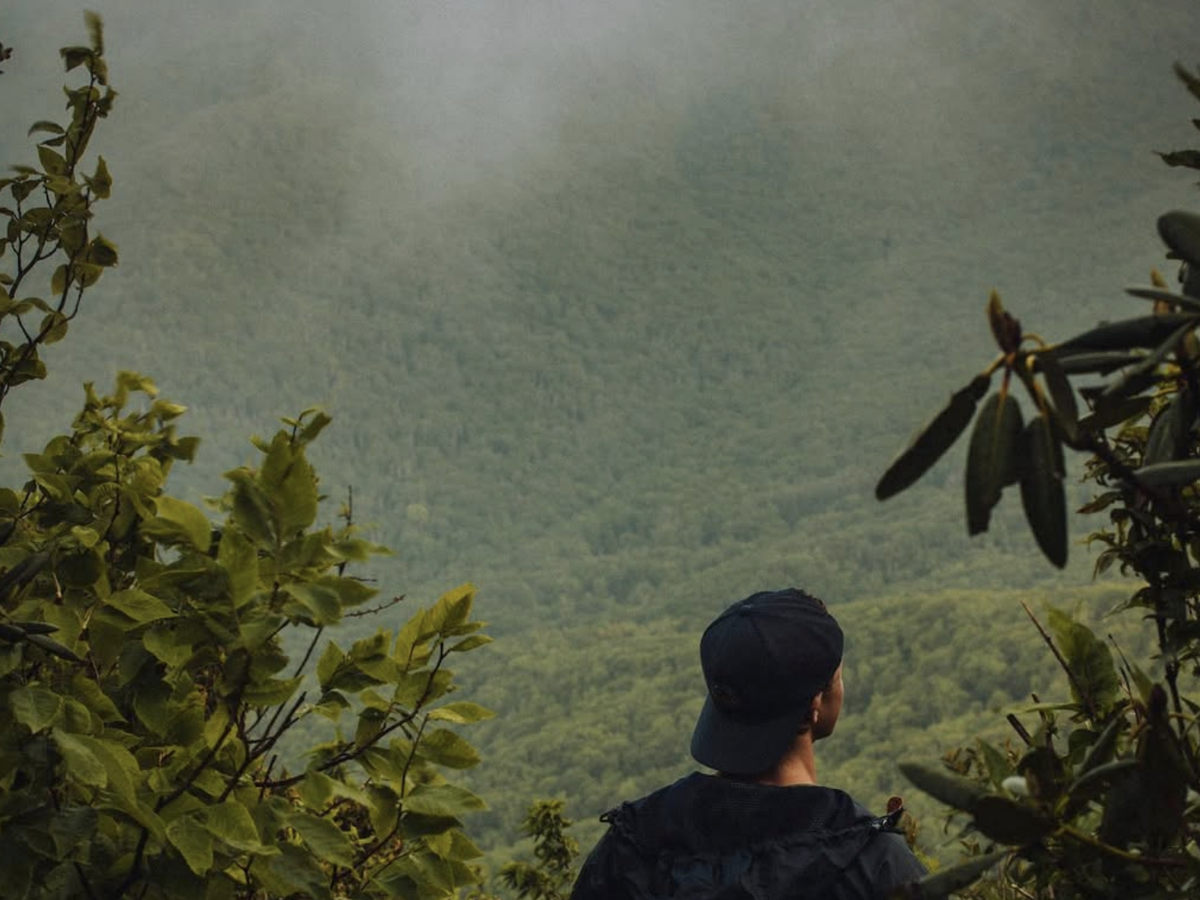
Black Balsam Knob
Photo Credit: @emilyanneloggins
GPS Directions Here — 1.4 Miles Round Trip (Out-and-Back via Art Loeb Trail)
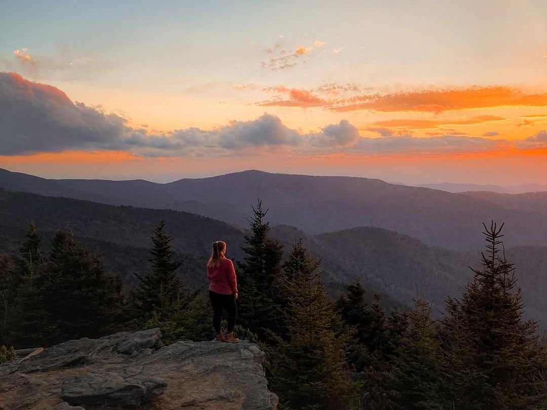
The Great Balsam Mountains form a high-standing nest of peaks, some of the loftiest in the Southern Appalachians, southwest of Asheville. Among numerous trails in this burly range, the short hoof-it up its second-highest summit, 6,214-foot Black Balsam Knob, is one of the must-do hikes in Asheville's backyard.
The main ascent to the wide-open heights of Black Balsam Knob is a 1.4-mile round-trip affair via the Art Loeb Trail, the trailhead for which sits just off the Blue Ridge Parkway at Milepost 420 about 26 miles from downtown Asheville. An introductory passage through high fir woods (their dark, resinous scent alone worth the drive) leads you onto the knob's sweeping summit bald, where the vistas sprawl to such heraldic Southern Appalachian tops as Mount Mitchell, Mount LeConte in the Great Smokies, Mount Pisgah, and Richland Balsam — the 6,410-foot crown of the Great Balsams and highpoint of the Pisgah National Forest. A metal plaque at the summit honors Art Loeb, the trail's namesake and beloved member of the Carolina Mountain Club.
Summit temperatures can run 15-20 degrees cooler than in Asheville, and wind exposure is significant. Bring a windbreaker even in summer. Check Parkway road conditions before heading out — this section closes periodically for snow and ice.
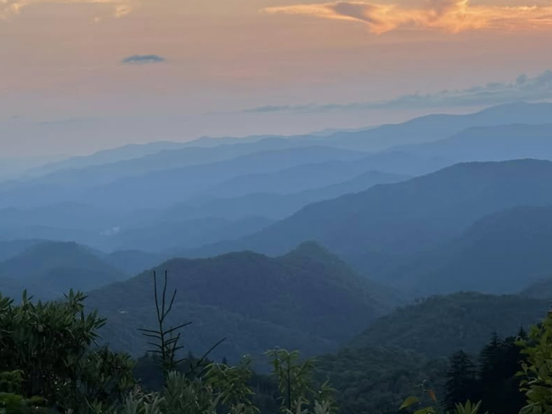
Cold Mountain
Photo Credit: @31countphotography
GPS Directions Here — 10.6 Miles Round Trip (Out-and-Back via Art Loeb + Cold Mountain Trails)
The third and most remote summit hike we're featuring in the Great Balsams, 6,030-foot Cold Mountain, makes the pyramidal acme of the Shining Rock Wilderness the biggest wilderness area in North Carolina and one of the first designated under the 1964 Wilderness Act. Literary and cinematic fame precedes it: Charles Frazier's bestselling novel Cold Mountain and the 2003 film adaptation brought this peak's name into living rooms across the country, but the mountain was drawing devoted hikers long before Hollywood came calling.
Getting to the summit and back from the Daniel Boone Boy Scout Camp via the Art Loeb Trail for 3.8 miles to Deep Gap, then the Cold Mountain Trail for another 1.5 miles to the top, sees you cover 10.6 miles round-trip and roughly 3,000 feet of huff-and-puff elevation gain. Allow 6-7 hours. The trail is well-worn but not blazed through the wilderness, so come with a map.
But boy, is it worth it: an opportunity not only to bask in the peak's expansive panorama, but also to experience true backcountry ambiance in one of the wild hearts of the Southern Appalachians.
Waterrock Knob
Photo Credit: @savannalrick
GPS Directions Here — 1.2 Miles Round Trip (Out-and-Back)
The Plott Balsams are a handsome and impressively elevated Southern Appalachian range whose relative obscurity stems from their perch between the higher yet and more massive blocks of the Great Smokies to the northwest and the Great Balsams to the southeast. Named for settler Henry Plott, also the namesake for North Carolina's state dog, the Plott Hound, bred for Southern Appalachian bear-hunting, the mountains culminate with 6,292-foot Waterrock Knob, the 16th-highest peak in the eastern United States, and an easy summit hike in a range mostly lacking in those.
It's also one easily reached from Asheville in under an hour via the Blue Ridge Parkway, where, at Milepost 451.2, you'll find that All-American Road's highest-set (5,820 feet) visitor center and the trailhead for Waterrock Knob. The hike itself is short, just 1.2 miles round-trip, but steep, gaining 412 feet in elevation. The first quarter-mile is paved, ending at a rocky-walled overlook where you can catch your breath before the trail transitions to a rockier, wilder climb.
Even if you don't have time or inclination for the summit, the parking lot offers ravishing vistas from the heart of the Blue Ridge Mountains, with views extending beyond nearby Plott Balsam summits, such as Yellow Face Mountain, to many eminences in the Great Smoky, Great Balsam, and Roan Highland/Unaka Ranges. Arrive early (or linger late): Waterrock Knob is one of the finest sunrise and sunset vantage points in all of western North Carolina, and its near-zero light pollution makes for exceptional stargazing. The visitor center is open mid-April through October.
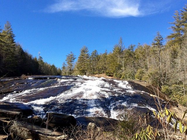
Bridal Veil Falls
Photo Credit: @markpacetti
GPS Directions Here — 4.4 Miles Round Trip via High Falls Access Area (includes High Falls)
An hour or so south of Asheville, DuPont State Recreational Forest showcases a series of showstopper Blue Ridge waterfalls along the Little River and Bridal Veil Falls may be the most dramatic of them all. The 4.4-mile round-trip hike from the High Falls Access Area is an easy ramble along wide, gently graded gravel roads, making it accessible for hikers of all ages and an equally excellent mountain bike route.
You'll first cross a picture-perfect covered bridge above the brink of High Falls to hikers of all ages and an equally excellent mountain-bike ride over a 125-foot plunge over a broad granite chute that's a stunner in its own right. Continuing south along Conservation Road past Lake Dense and forest-cradled Lake Julia, you'll eventually reach Bridal Veil Falls Road, which leads another half-mile to the falls themselves. The spectacle: a dramatic two-tiered 120-foot waterfall that drops first in a freefall from an angular ledge, then surges as a lengthy, shimmering cascade along slanted granite into a rocky plunge pool spanning roughly 800 feet wide. You may recognize it, Bridal Veil served as a filming location for both The Last of the Mohicans and The Hunger Games.
An observation platform and flat rock outcroppings provide perfect perches for photos and a long, well-earned lunch. Note that walking on the rocky sides of the falls is no longer permitted due to injuries.
Find the Perfect Launchpad for Greater Asheville Hiking & Summit-Hopping
Bear in mind the above list is very much at the scratching-the-surface level: What about Craggy Pinnacle? Bearwallow Mountain along the lip of the Hickory Nut Gorge? Lover’s Leap overlooking Hot Springs, NC, and the French Broad? The vast, view-dazzled balds of Roan Mountain, one of the Southern Appalachians’ magic spots?
Well, consider your adventuring work cut out for you when vacationing in Asheville! And on that count: Look no further than The 100 Collection partner Greybeard Rentals helmed by local outdoors-lover and Asheville trails aficionado Chip Craig—for the perfect getaway in one of the East's premier mountain towns (and cultural hubs). From secluded upscale cabins to lakefront lodges, Greybeard Rentals has got you covered with each and every Asheville-area property hitting that exhaustive standard of luxury and hospitality. The 100 Collection trademarks in.